What is the Texas Community Assessor?
Community Assessor is a web-mapping application that allows approved assessors to create and manage wildfire risk assessments at the community, subdivision, or individual home level. All information is collected using a modified version of the National Fire Protection Association’s (NFPA) 1144 Standard for Reducing Structure Ignition Hazards from Wildland Fire. The data collected is stored in a centralized database to extract community wildfire risk information within an area, such as a city or county. Access to the Community Assessor requires an approved user account.
Who uses it?
The application is used by Texas A&M Forest Service Mitigation and Prevention Program Coordinators and Specialists, WUI Coordinators, local fire departments as well as homeowners or neighborhood associations to set up assessment projects for cities and counties, delineate community boundaries within a jurisdiction, assign team members to projects, conduct wildfire risk assessments for those communities while out in the field, and then produce data and reports to be used for developing wildfire risk management strategies for communities. Specifically, Texas A&M Forest Service WUI Coordinators utilize these reports for developing Community Wildfire Protection Plans (CWPP) and to inform Firewise USA® risk assessments.
What can it do?
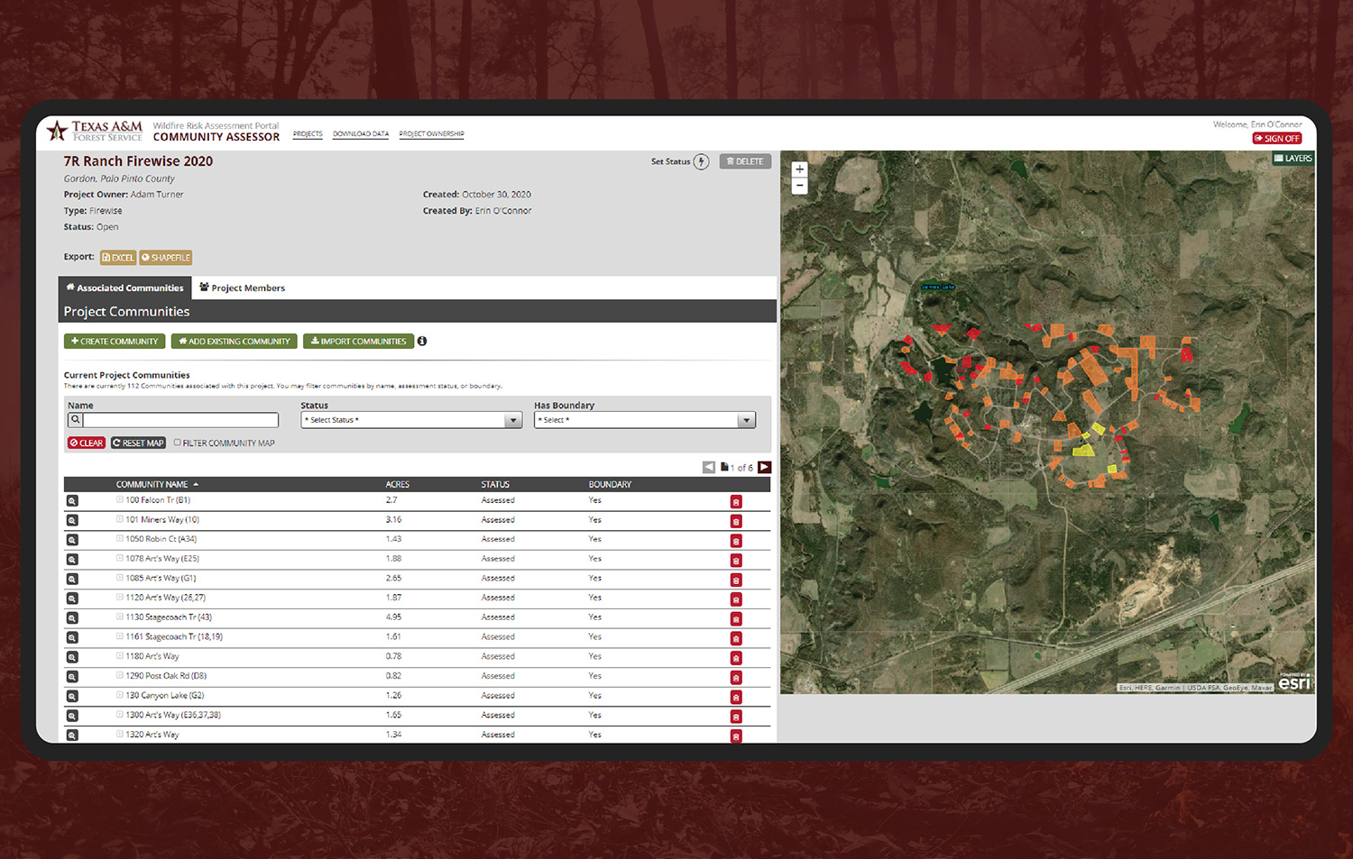
The Community Assessor consists of a web application and a field-based mobile app. It allows authorized users to sketch out community boundaries on a map and enable assigned project team members to complete community wildfire risk assessments, search and download data, and run reports for communities throughout the state of Texas. The main features of the app include:
- Role-based access for WUI Coordinators, managers, and local fire departments
- Easy-to-use web-based organization of projects and communities within projects
- Community boundary map delineation tools
- Ability to assign project team members to specific communities
- Mobile community wildfire risk assessment forms (iOS and Android)
- Associate photos to community risk assessments
- Report with detailed community information
- Community Hazard Rating / Scoring
- Detailed mitigation strategies
Applications from the field: Firewise USA®
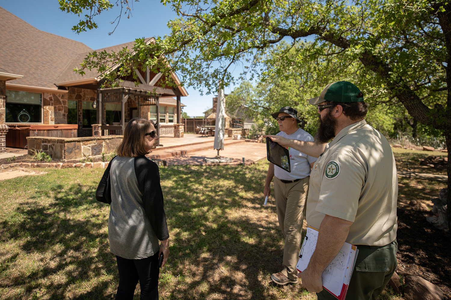
7R Ranch, located in Gordon, Texas, is a recognized Firewise USA® Site and recently completed NFPA’s Sites of Excellence pilot program. Sites of Excellence was a 24-month pilot program designed to increase resident participation in active wildfire risk reduction through a focused approach. The challenge to each participating site was to have 100% participation of homes within the designated pilot boundary and to complete identified mitigation tasks within 30 feet of every home, based on recommendations from individual assessments.
To complete the assessments and to capture a baseline risk rating for the community, residents, the fire department, and Texas A&M Forest Service teamed up to assess every home in the community. Through the Community Assessor application, each home was given a rating and every homeowner received the report printout with mitigation strategies to guide risk reduction work on their property.
Applications from the field: Community Wildfire Protection Plans
Texas A&M Forest Service works with local emergency management, fire departments, community leaders and elected officials to develop Community Wildfire Protection Plans to help plan and prepare for wildfires. A CWPP is a collaborative approach to wildland fire protection and mitigation that prioritizes fuels reduction and treatment of structural ignitability. Wildfire risk assessments are an integral part of a CWPP in helping to identify and prioritize specific mitigation projects and strategies for areas most at risk for catastrophic loss during a wildfire event.
The City of Bryan utilized Community Assessor to complete risk assessments during a recent update of their plan. To see how the city incorporated the data and information gathered, check out their plan: https://bit.ly/3wH4TCP.
How can I request access?
While anyone can view the results of a community risk assessment on the Texas Wildfire Risk Explorer, access to the Community Assessor app requires a TxWRAP user account and Texas A&M Forest Service approval. If you’re already working with your local WUI Coordinator, ask them about Community Assessor or contact us through the form on the homepage for more information.